


HuntStand: GPS Maps & Tools
2.59.68K Reviews
App Specs
- Version
- 8.1.9
- Updated On
- License
- Free
- Downloads
- 1,000,000+
- Developer
- GSM Outdoors
- Categories
- Sports
- Platform
- Android, iOS
Screenshots
 Analysis by AppCompare
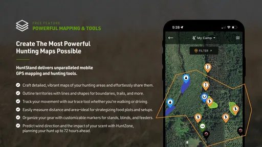
In my experience, a map app earns a lasting place on my phone only when it helps before a trip and still proves useful once I’m outside. HuntStand: GPS Maps & Tools is aimed chiefly at hunters, but its mapping and trip-planning tools can also suit people who regularly explore unfamiliar outdoor areas. The first few days are appealing: you can mark places, look over map views, and get a feel for how a planned outing might fit together. The more important question is whether those habits remain worthwhile after the novelty wears off.
Who benefits from the first week
I’d start by treating HuntStand as a planning tool rather than expecting it to make decisions for me in the field. Before a trip, I can look over the area, save useful map information, and mark the places I want to remember. That small bit of preparation is what makes a GPS map more than a screen to glance at: it gives me a reason to open it again later and a record I can build on.
A realistic use case is getting ready for an early weekend outing in a place I don’t know well. I can check the map at home, save the area for offline use, note a meeting point, and make a few waypoints for locations I may need to find again. Once I’m there, those marks can help me stay oriented without relying on a continuous mobile connection. I still wouldn’t treat a phone as my only safety plan, but having the area prepared is a practical advantage.
That workflow is especially appealing to hunters who revisit the same ground and want a personal record of places and conditions. A hiker who only follows familiar, clearly marked routes may get more from a simpler navigation app; someone who likes to annotate an area and return to those notes has a better reason to try this one.
What keeps it useful month to month
The lasting value comes from combining the map with the journal. A saved waypoint is useful in the moment, but a note about why I marked it can make it more meaningful on a later visit. Recording the weather, location, or wildlife I noticed turns a single outing into information I can compare with future trips. That is a slower payoff than an instant navigation fix, and it depends on actually entering notes rather than merely installing the app.
I’d keep the habit lightweight. After a trip, I could add only the details I’m likely to care about later: where I went, what conditions were like, and which points are worth checking again. There’s little benefit in turning every outing into a long report if that makes me stop logging altogether. A few useful entries are more likely to make the journal earn its place than an ambitious routine I abandon.
Sharing maps and locations can also help when a group needs to coordinate around the same area. I’d use it to communicate a clear meeting point or pass along relevant map context, while agreeing on a backup plan before leaving. A shared location is a convenience, not proof that everyone’s phone will stay connected or that all group members have prepared the same way.
Worth Reading Before You Choose

EA SPORTS FC Mobile 26 Is a Bigger Football Game, but It Takes Time

Flipboard Shows What News Apps Must Do Beyond the Feed

Switching to Android Auto Means Rethinking Your Driving Routine

Google Calendar Makes a Crowded Week Easier to Manage

Ludo King Makes the Most of the Minutes Between Plans

Baby Panda World Brings Quick Play to Modern Phones, but Its Game Library Feels Busy
Preparation, upkeep, and points of friction
Offline maps are valuable only if I remember to prepare them while I still have a connection. Before setting off, I’d open the area I expect to visit and make sure it is available offline, then check that the phone has enough battery for the outing. This is an easy task to overlook when plans change at the last minute. The app can help with navigation, but preparation is still part of using it responsibly.
Map details and saved marks also need occasional attention. If I keep adding waypoints without labels or context, the map can become harder to interpret instead of more useful. I’d use names that explain why a spot matters and remove or revise old marks when they no longer help. That bit of maintenance is modest, but it’s the difference between a personal map and a cluttered collection of pins.
Weather information and alerts are helpful planning aids, not a guarantee of safe conditions. I’d check the forecast before leaving, keep an eye on conditions as they change, and avoid letting an alert replace local judgement. The same caution applies to relying on a phone outdoors: battery life, signal, and the limits of a small screen all affect how useful a digital map feels on a particular day.
There can be friction in the amount of preparation involved. Someone who wants to open an app and immediately follow a straightforward route may find layers, saved areas, journaling, and sharing more than they need. I’d also expect the experience to feel more worthwhile for people who return to their maps and notes than for casual users who take only one occasional trip. An app with an average rating of 2.8 from around 22,000 ratings has a mixed reception, so I’d go in ready to judge the day-to-day experience for myself rather than assuming every feature will suit my workflow.
How it compares with simpler options
Compared with a basic map app, HuntStand’s appeal is the hunting-oriented combination of customizable maps, waypoints, weather planning, and a journal. A general navigation app may be the better choice if I mainly need turn-by-turn directions or a quick route on established paths. A paper map remains a sensible backup when electronics are unreliable, while a plain notes app can be enough for someone who only wants to record observations. The trade-off is that those alternatives may not bring map marks and trip notes together in the same outdoor-focused workflow.
I’d choose based on what I want to repeat. If my trips involve returning to places, keeping track of conditions, or coordinating with companions, this broader toolkit has a purpose. If I rarely revisit an area and only need basic directions, a simpler option is likely easier to maintain. The app is free to download, with in-app purchases ranging from $5.99 to $99.99 per item, so I’d first work out whether its core routine fits before considering any paid extras.
Getting Started with HuntStand
Let's dive into what makes HuntStand such a handy tool. The first thing you’ll notice when you download the app is its clean and intuitive interface. Even if you’re not the most tech-savvy person, setting it up is a breeze. Once you’re in, you can start exploring its vast array of features designed to enhance your outdoor experience.
Mapping Your Adventure
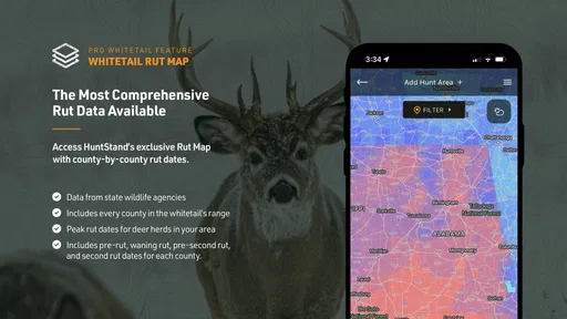
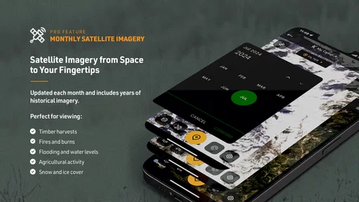
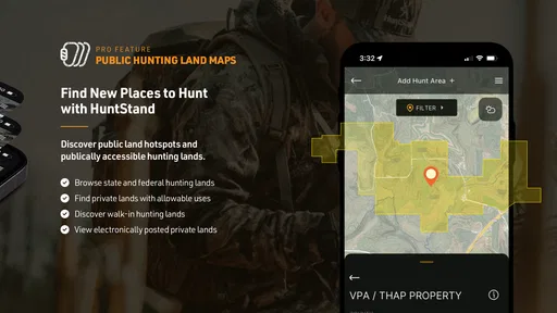
One of the standout features is the GPS mapping tool. Whether you're a hunter, hiker, or just someone who loves the great outdoors, having a reliable map is crucial. HuntStand offers detailed maps that you can customize with waypoints, trails, and boundaries. It’s like creating your personal treasure map! Plus, you can switch between different map views to get the best perspective of your surroundings.
What’s cool is that these maps are accessible offline. So, even when you’re miles away from civilization, you won’t be left in the dark. Just make sure to download your maps beforehand, and you’re good to go!
Weather Forecasting
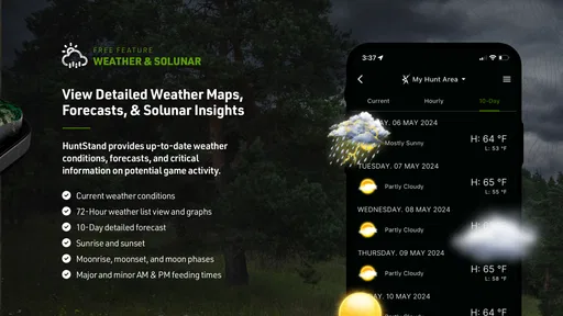
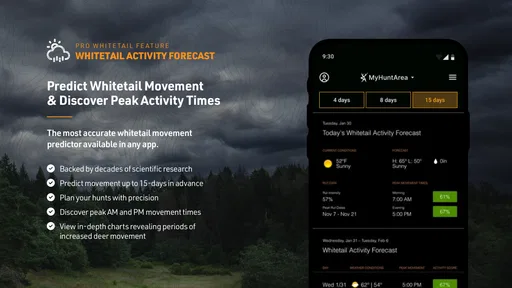
Weather can make or break your outdoor plans, right? That’s why the built-in weather feature is such a lifesaver. HuntStand provides up-to-the-minute weather updates and forecasts, so you can plan your trips with confidence. You can also set alerts for specific weather conditions. It’s like having your personal weatherman at your fingertips.
Journaling Your Journey
If you love keeping track of your adventures, the app's journaling feature is perfect for you. It allows you to log details about your trips, including locations, weather conditions, and even the game you’ve spotted or hunted. Over time, you’ll build a rich history of your outdoor experiences, which is super satisfying to look back on.
Sharing and Networking
For those who enjoy sharing their experiences or coordinating with friends, HuntStand makes it easy. You can share maps and locations with your buddies, making it a fantastic tool for group trips. Plus, there’s an active community of users where you can exchange tips and stories. It’s like being part of a giant, friendly hunting club.
Tips and Tricks
Now, before you head out, here are a few tips to make the most of HuntStand. First, spend some time familiarizing yourself with the map features. Play around with adding different layers and see how they can enhance your planning. Also, always remember to check for updates and download maps ahead of time, especially if you’re going off-grid.
Another pro tip? Take advantage of the weather alerts. They’re incredibly helpful for planning the best time to head out, ensuring you have a safe and enjoyable experience.
Lastly, explore the community section. You’ll find a treasure trove of advice and stories from users just like you. It’s a great way to learn new things and maybe even make some new friends along the way.
GSM Outdoors develops this free sports app, which is rated Everyone and has been available since November 21, 2013. Its current version is 8.0.66, and it has passed one million installs. Those details suggest an established product, but they don’t remove the need to see whether its map-centered routine matches how I actually spend time outdoors. The rating and the sizeable number of written reviews point to a divided user response, so I’d test the basics before building a trip-planning habit around it.
What to check before depending on it
For a first outing, I’d keep the test simple: prepare a small area for offline access, add one or two clearly named marks, and see whether I can find and understand them without stopping to fiddle with the phone for too long. That reveals more than browsing every option at home. If the map is easy to read in the conditions I actually encounter and the saved marks make sense later, I can expand my use gradually.
I’d also decide in advance what information I’m comfortable sharing. A location can be useful to a hunting partner, but precise outdoor plans may be personal. Sharing should be deliberate: send only what the other person needs, and make sure the group knows which point is the agreed meeting place. That simple habit prevents a map full of ambiguous marks from becoming a source of confusion.
One useful trade-off is detail versus legibility. Adding layers and numerous waypoints may make planning richer, but it can also crowd the view when I need a quick answer. I’d switch on only the map information relevant to the task and keep important locations distinguishable with concise names. The best setup is not necessarily the most detailed one; it is the one I can read quickly when attention is divided.
Another question is whether this is a good fit for a beginner. I think it can be, provided the person is willing to explore the map before heading out instead of expecting every outdoor decision to be automatic. Someone who wants a no-setup route guide may feel more comfortable with a simpler navigation tool. Likewise, if I’m not going to revisit locations or write any notes, the journal and saved-map workflow loses much of its value.
A habit that can survive the novelty
To keep using the app, I’d attach it to a routine I already have: check the area while planning, download what I’ll need, then add a short note when I get home. That makes the app useful at three distinct moments without requiring constant attention. I wouldn’t open it simply because it has many tools; I’d open it when a specific map, weather check, or past observation can improve the next outing.
Maintenance is not difficult, but it is real. Saved areas should match upcoming plans, old waypoints should remain understandable, and the phone itself needs enough charge for navigation. If I’m preparing for a longer or unfamiliar trip, I’d carry an independent backup map and tell someone where I’m going. Digital convenience is strongest when it supports sensible preparation instead of replacing it.
For people who hunt regularly, revisit the same ground, and enjoy learning from their own notes, HuntStand: GPS Maps & Tools has a plausible reason to stay installed beyond the first week. It is less compelling for occasional walkers who want only uncomplicated directions, or for anyone who dislikes organizing map data and keeping a journal. My verdict is that its value is earned through repeat use: start with one prepared outing, keep only the features that help, and let the saved knowledge build naturally. Whether you’re a seasoned hunter or just someone who loves exploring nature, it can make planning more organized, but I’d treat it as a useful companion rather than a substitute for judgement, preparation, or a backup plan.
Pros
- Detailed and accurate GPS mapping.
- Offline maps available for remote areas.
- Customizable map layers.
- Weather updates and forecasts included.
- User-friendly interface for easy navigation.
Cons
- Some features require a premium subscription.
- Occasional app crashes reported by users.
- Limited offline storage for maps.
- Battery drain can be significant during use.
- Advertisements in the free version can be intrusive.
FAQs for HuntStand: GPS Maps & Tools
What features does HuntStand offer for hunters?
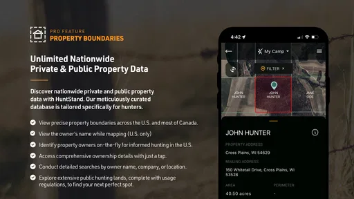
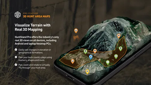
HuntStand provides a comprehensive suite of tools for hunters, including GPS maps, property boundaries, weather forecasts, and hunting journal capabilities. Users can access land management features, detailed mapping tools, and collaboration options to share plans with fellow hunters. These features aim to enhance the overall hunting experience by offering precise and reliable data.
Is HuntStand available for both Android and iOS devices?
Yes, HuntStand is available for both Android and iOS users. It can be downloaded from the Google Play Store for Android devices and the Apple App Store for iOS devices. This cross-platform availability ensures that hunters can access the app’s features no matter which operating system they prefer.
Are there any subscription fees for using HuntStand?
HuntStand offers both free and paid versions. The free version includes essential features, but upgrading to HuntStand Pro unlocks additional benefits, including offline maps, property ownership information, and advanced mapping tools. Subscription fees for HuntStand Pro vary, and users can choose between monthly and annual plans to suit their needs.
How accurate are the maps and property boundaries in HuntStand?
HuntStand is known for providing highly accurate maps and property boundaries. The app uses reliable data sources to ensure that users can trust the information for planning their hunting trips. However, it’s always recommended to verify property boundaries and other critical data with local sources for complete accuracy.
Can HuntStand be used for activities other than hunting?
Yes, while HuntStand is primarily designed for hunting, its versatile mapping and GPS functionalities can be beneficial for other outdoor activities such as hiking, camping, and land management. The app's ability to track movement, mark points, and share locations makes it a useful tool for various outdoor enthusiasts.


